
One of nature's most powerful and destructive forces, hurricanes are capable of causing widespread devastation and loss of life. While these storms are infamously unpredictable, understanding their lifecycle can help us better prepare for and respond to these natural disasters.
Formation and Early Development
Meteorologists have divided the development of Atlantic hurricanes into four stages: Tropical disturbance, tropical depression, tropical storm, and hurricane.
- Tropical disturbance: Warm ocean waters condense to form clouds, releasing heat into the air. The warmed air rises into the column of clouds, and as that moving column encounters more clouds, it becomes a cluster of thunderstorm clouds.
- Tropical depression: Rising motion and heat release within the cluster of thunderstorms causes the atmospheric pressure to drop, leading to an increase in wind speeds around a center of circulation
- Tropical storm: Wind speeds reach 39 mph, and the storm gets a name. As a public safety measure, TempestOne provides free access to their Ops Console to track named storms.
- Hurricane: Wind speeds reach at least 74 mph. Cloud tops can exceed at least 50,000 feet high and the whole system can be 125 miles or more across. With further organization, the clear area at the center of circulation called the eye can form, often around 5 to 30 miles wide.
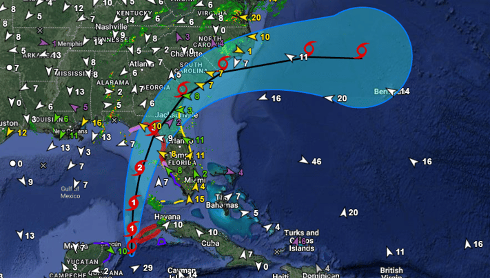
Hurricane Idalia
Hurricane Idalia began its journey as a tropical disturbance over the Eastern Pacific basin off the Central America coast on August 24. After crossing into the western Caribbean Sea, the warm ocean waters provided the necessary heat and moisture to fuel the storm's development. As the disturbance moved northward, it began to organize and strengthen. While the disturbance was located near the northeastern Yucatán Peninsula on August 26, it was upgraded to Tropical Depression Ten. The depression became Tropical Storm Idalia on August 27 after the storm's winds had increased to 40 mph. On August 29, after passing near the western tip of Cuba, the storm developed sufficiently to be classified as a Category 1 hurricane As it moved over even warmer ocean temperatures in the Gulf of Mexico, Hurricane Idalia rapidly intensified from Category 1 to 4 intensity in just 24 hours.
Rapid Intensification
Rapid intensification is a phenomenon that occurs when a tropical cyclone's wind speeds increase dramatically over a short period, typically an increase of at least 35 mph within 24 hours. In the case of Idalia, it was a Category 1 hurricane with 75 mph sustained winds early on August 29. By the next day, it was a monstrous Category 4 with sustained winds of 130 mph, a staggering increase of 55 mph in just 24 hours.
Idalia's path took it through an environment conducive to rapid intensification, featuring warm sea surface temperatures, low wind shear, and high atmospheric moisture content. Exceptionally warm ocean temperatures in the Gulf of Mexico and around southern Florida this year have alarmed scientists. The average sea surface temperature in Idalia’s path was recently measured at nearly 88 degrees Fahrenheit — a record since data collection began there in the early 1980s.
Landfall and Impact
Hurricane Idalia made landfall the morning of August 30, near Keaton Beach, Florida, with maximum sustained winds of 125 mph, unleashing its fury as a Category 3 storm. The combination of powerful winds, heavy rainfall, and storm surge led to widespread damage and flooding. Coastal communities bore the brunt of the impact, with homes, businesses, and infrastructure suffering extensive damage. Power outages were widespread, leaving thousands without electricity.
Once inland, the system quickly weakened as it pushed through Northern Florida, downgraded to a tropical storm later that day after crossing into Georgia. From Georgia, the storm continued to lose momentum as it passed through the South Carolina coast and emerged into the Atlantic Ocean on the morning of August 31. Later that day, Idalia transitioned into a post-tropical cyclone near Cape Hatteras, North Carolina. Even as it weakened over land, the storm continued to produce heavy rain, with Tempest Home Weather Stations in Ocracoke measuring as much as 10 inches of rain.

Response and Recovery
In the aftermath of Hurricane Idalia, a coordinated response effort was launched to assist affected communities. Local, state, and federal agencies collaborated to provide relief and aid to those affected by the hurricane. Shelters were opened to provide temporary housing for displaced residents, and food and supplies were distributed to those in need. Utility crews worked around the clock to restore power and other essential services.
Although the damage is significant, the devastation was not as immense as it could have been. Some have credited improved forecasting for spurring residents to evacuate the right places well ahead of time and the fact that Idalia made landfall in a less-populated area than past hurricanes. The lessons learned from this hurricane underscore the importance of both community and individual preparedness and early warning systems.
Those returning to destroyed or significantly damaged homes now face the daunting question of whether to stay and rebuild or relocate. Many residents and researchers alike question the wisdom of continuing to rebuild communities in low-lying areas vulnerable to storm surges, flooding, and some of the fastest sea level rise in the world. Major insurance companies may have already largely answered that question, with most having already pulled out of Florida, leaving many home and business owners unable to recoup their losses.
Mitigating Extreme Weather Events
Hurricane Idalia's journey, from its formation over the Atlantic Ocean to its devastating impact on coastal communities, serves as a stark reminder of the power and unpredictability of nature. While we cannot control the weather, we can mitigate its effects through preparedness, timely warnings, and effective response efforts. As we reflect on the events surrounding Hurricane Idalia, let it be a testament to the resilience of communities and the importance of being ready for whatever challenges Mother Nature may bring our way.
Back to: Articles