Why Weather Awareness Matters.
Any good fishing captain checks the weather constantly and has multiple game plans for all kinds of potential conditions. Along the coast of the Outer Banks, the dog days of late summer can still offer some hot fishing if you play the conditions and tides right. Late-summer fishing success on the Outer Banks is primarily dictated by the wind. That is you want to be fishing where the wind and tides work in your favor. A strong southwest wind may leave one area calm and productive while making another uncomfortable or unfishable. A northeast wind can reverse those conditions entirely. Using FishWeather’s wind observations, tide stations, and forecast models lets you identify those shifts before leaving the dock and choose the best plan for the day.
Atlantic high pressure remains the dominant weather pattern in late summer, producing regular SW to SSW breezes along the Carolina coast. These winds typically strengthen during the afternoon as sea breezes develop. Consistent wind patterns create consistent fishing conditions. Match your target species, water conditions, and vessel capabilities to those conditions, and you’ll greatly improve your chances of success. Ignore factors like water clarity, depth, salinity, or launch a small boat into exposed open water, and you may find that you not only aren’t catching much, but also could end up in a hazardous situation.
Understanding Wind-Driven Water Levels in the Sounds
In my backyard, the Pamlico and Albemarle Sound are vast, shallow inland seas that see little lunar tide movement. Rather, sustained winds drive water levels up and down. The SSW/SW winds that blow across these expanses tend to keep water levels high on the eastern side of the sounds, and depending on recent rains can push saltier water and species far up the Albemarle and Currituck Sounds where you may catch a largemouth bass on one cast and a red drum on the next.
The Sou’wester
Consistent fishing for red drum, speckled sea trout, bluefish, and flounder, occurs in late summer on both sides of the sounds as long as current and bait are present. Smaller boats and even kayaks can fish the mainland side of the sounds, particularly in the mornings, as SSW/SW breezes provide calmer flat-water conditions in the lee of land. However, to comfortably fish the eastern side of the sound behind the barrier islands a larger vessel is advised.
Similarly, SSW/SW breezes provide calm conditions in the nearshore waters off Oregon Inlet, and many smaller center consoles can have safe comfortable access to the nearshore reefs and trolling grounds, where spanish mackerel, bluefish, amberjack, king mackerel, triggerfish, and even slinger dolphin are available. Winds tend to trend more due south into the afternoons, though, so smaller vessels should plan to head to the ramp around lunchtime or deal with some chop on the way back to the inlet. Much to the chagrin of surf casters, consistent SSW/SW breezes often make surf fishing less productive along the east facing beaches from Rodanthe to Corolla, because warmer surface water is pushed offshore, with colder brown water, frequently in the low to mid 60s, upwelling along the beach.
The Nor’easter
Of course, the wind does not always blow SSW/SW in August or September, as weak frontal boundaries still manage to sag through the region, typically causing NE winds to spread down the coast. Now considering that NE winds are nearly 180 degrees opposite the predominant SSW/SW wind direction. The inverse of all the scenarios listed above becomes true. The nearshore waters out of Oregon Inlet become a choppy mess, and the west sides of the sounds will be churned up with high water. So, smaller boats will want to target the east sides of the sounds for calmer conditions. Conversely, surf fishing typically picks up with warm clear water and baitfish pushing into the beaches.
Applying Lessons Learned to Regions with Different Coastal Orientation
The coastline orientation changes south of Cape Point on Hatteras Island, and you will find that the NE winds that drive up unruly chop along the east facing beaches from Buxton to Corolla provide a calmer surf zone environment from Frisco to Ocracoke barring the presence of any large swell, while raising water levels and producing rough conditions on the north facing soundside. So, smaller center console type vessels can fish those nearshore zones in relative comfort. Likewise, stronger SW/SSW winds will produce a messy, choppy ocean, while the soundside offers more manageable conditions for anglers in smaller boats or even kayaks. One can apply these general rules of thumb to other areas down towards the Crystal Coast, or even further inland towards the Inner Banks. Just adjust your shoreline exposure accordingly. The table below offers a snapshot of these general rules of thumb.
| Northeast/East Winds | South-Southwest/Southwest Winds |
| Calmest sound conditions west of the beaches and Roanoke Island | Calmest sound conditions east side of mainland Dare/Hyde counties, also east side of Roanoke Island |
| Calmest nearshore ocean conditions from Frisco to Ocracoke | Calmest nearshore ocean conditions from Rodanthe to Corolla |
| Better surf fishing the from Buxton to Corolla | Better surf fishing from Frisco to Ocracoke |
The Mullet Run
One more factor to consider outside of the wind and sea conditions is the onset of the mullet run, which typically occurs in late August or early September coinciding with one of the first stronger NE wind events behind a frontal boundary. The mullet run is the seasonal migration of mullet from inshore nursery areas to the ocean where they head southward. This mass migration of baitfish triggers the movement of gamefish to choke points, where they can ambush the near constant stream of mullet moving towards Oregon and Hatteras Inlets. As such, when conditions allow it is wise to focus fishing efforts near the inlets, once the mullet run has begun, whether that be in the ocean or soundside. Lunar tides do play a larger role in the waters near the inlets, so check in with the nearest tide station to plan accordingly for the area you plan to fish.
Putting FishWeather to Work
It is not unusual for frontal boundaries to stall over Oregon Inlet, or Cape Point during late summer. This corresponds to dropping barometric pressure, and frequently overcast skies. In other words, very fishy weather. Indeed, at the time of writing, a frontal boundary is draped across Oregon Inlet, with moderate NE breezes in place to the north, and lighter SW/W breezes to the south, as seen in the image below.
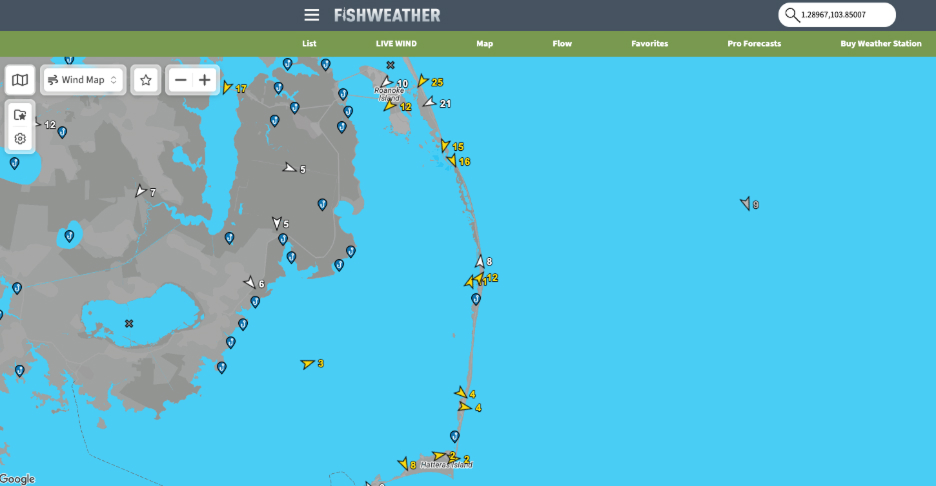
Very different conditions will present themselves across a relatively short distance in a scenario like this, so having access to this data can give you the confidence to make a short drive to target the most favorable conditions.
Additionally, if you are planning for conditions over the near term, it is wise to cross reference available observational data with the most recent model forecasts to determine which of the available models is performing best under a given scenario. This lends more confidence to the forecast for the remainder of the day.
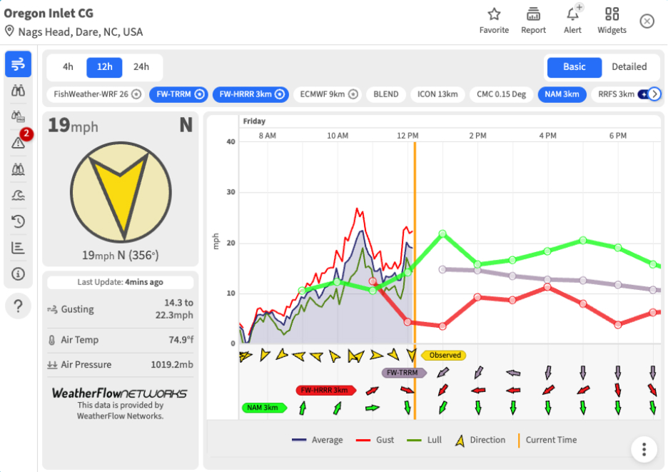
For instance, in the figure below I have selected the Oregon Inlet Coast Guard wind meter and overlaid several model forecasts on the graph. At a glance you can see that the NAM 3km model seems to be doing quite well, and given the majority of the other models also depict N/NE winds through sunset. I would be inclined to believe the forecast for northerly breezes in the upper teens to near 20 mph will continue through the afternoon.
All of this is to say, that there are many options along the Outer Banks and Inner Banks to fish in conditions that are safe and comfortable for your vessel, provided you use the forecast and observational information available to you within the FishWeather app. With the densest network of coastal wind observations available, you can cross check what the forecast models are projecting against reality on the water. This is invaluable information for anglers and savvy boaters alike.