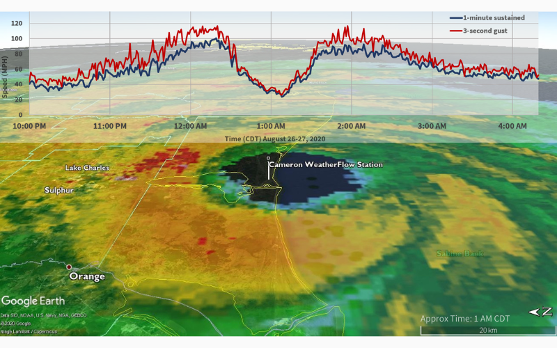
Santa Cruz, Calif. – September 03, 2020 – WeatherFlow Inc., a leading weather technology company, tracked and reported critical weather observations in real-time as Hurricane Laura came ashore in Louisiana on August 27. Newly released data and images show the extreme winds and enduring power of the storm, as the category 4 hurricane maintained its strength while advancing inland.
WeatherFlow’s data was shared with NOAA (the National Oceanic and Atmospheric Administration) during the event. With all storms the company provides extensive observational data to relevant government agencies in order to better inform storm warnings, advisories, and emergency relief efforts.
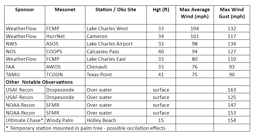
Hurricane Laura made landfall at 1 a.m. CDT on August 27th, with the storm’s eye passing directly over WeatherFlow’s Hurricane Network station in Cameron, located on the southwestern coast of Louisiana. Cameron was the first weather station to report hurricane-force winds, with 101 mph maximum sustained winds and a 117 mph gust.

Thirty miles inland from Cameron, near Lake Charles, rugged mobile weather stations were deployed as part of WeatherFlow’s partnership with the University of Florida’s Coastal Monitoring Program. As Laura traveled inland, these stations were placed in the storm’s path and captured its unusual endurance.
“The data reported by our inland mobile stations was especially interesting,” explained WeatherFlow Lead Meteorologist, Dr. Marty Bell. “They provided the first indication that, rather than weakening rapidly after landfall, as most hurricanes do, Hurricane Laura maintained its intensity for a considerable distance, with maximum sustained winds of 104 mph and a 132 mph gust reported some 30 miles from the coast.” The NOAA station at Lake Charles airport recorded similar wind speeds before it failed as a result of the storm.
WeatherFlow maintains an extensive industrial grade weather observing network which includes a set of weather stations known as its Hurricane Network. These are the only stations in the world guaranteed to survive and record hurricane force winds. It is common for observing stations to be damaged or lose communications during powerful storms, preventing them from reporting critical weather measurements. Designed specifically to withstand the extreme environment of landfalling hurricanes and other severe weather, the Hurricane Network stations have tracked more than 50 named storms and haven’t experienced a single failure in 13 years of operation
“Accurate wind data is critical to NOAA’s role in protecting lives, both during a given storm and to help better understand future threats,” said WeatherFlow CEO Buck Lyons. “The ruggedness and reliability of our weather stations enable the collection of data that is vital to ensuring public safety.”
While state and federal organizations provide weather monitoring at some key locations, recent years have seen an exponential increase in demand for more weather data. WeatherFlow significantly enhances existing data and fills data voids both by installing industrial grade stations and utilizing data from thousands of its Tempest Home Weather Systems. The rapid growth of the Tempest network, fueled by sales to citizens across the globe, is enabling better decisions on both local and international scales.
For more information about Weatherflow’s industrial observing networks or to access proprietary network data, please contact Jay Titlow at: jtitlow@weatherflow.com. To learn more about the Tempest system and participating in the Tempest network please visit www.weatherflow.com.
About WeatherFlow
WeatherFlow Inc. is a leading weather technology company, with over two decades of experience developing and applying progressive data modeling and forecasting techniques. The company currently operates the most advanced industrial grade weather station network of any private entity in the world, with clients including NOAA, and the US Coast Guard, and a number of highly regarded academic and corporate organizations.
WeatherFlow recently launched a new consumer-centric line of products and services, making its leading forecast and data analytics available to general consumers. The Tempest Home Weather System is available for direct purchase within the continental US, with international shipping expected to open in early 2021.