
By WeatherFlow-Tempest Meteorologist Shea Gibson
The 2026 Hurricane Season began on June 1st for the Atlantic basin. This year will uniquely differ from the past recent years as we have a few factors that will limit development from the beginning and through the bulk of the peak season. In this article, I will show you the hurricane season forecast 2026 from both NOAA NHC and from Colorado State University, where think tanks such as Phil Klotzbach adds valuable perspective to the tropics. I will also show some visual information to help you understand why our ongoing Atlantic hurricane season prediction will be different this year.
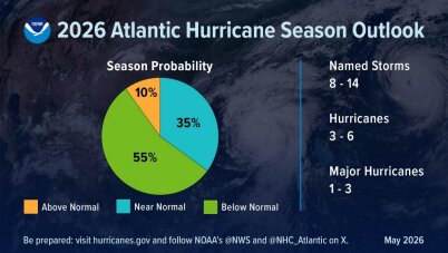
As far as the official hurricane season forecast provided by NOAA/NHC on May 21, 2026, they are calling for a 55% chance for a below average season with 8-14 named storms, 3-6 hurricanes and only 1-3 major hurricanes.
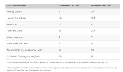
CSU issued their prediction earlier on April 9, 2026 and also agrees with a below average season with 11 named storms, 5 hurricanes and only 2 major hurricanes.
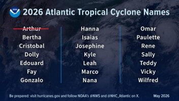
And here are the names as of June 20th, 2026, with Arthur already being used as a briefly lived, weak tropical storm on Thursday, June 18, 2026.
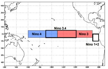
To understand why the below average predictions are being issued, let’s first start with the elephant in the room, which is the ENSO (El Niño Southern Oscillation) cycle that you’ve likely been hearing about in various media outlets. This particular weather event stems from the equatorial central Pacific, where a specific area called “Nino Region 3.4” is measured for sea surface temperatures and atmospheric conditions and averaged over a three-month period to tell us which phase of the ENSO we are in. If the surface waters in that area rise above 0.5°C above normal for the three-month average along with relaxing of the Easterly trade winds, then we go from Neutral (normal) to El Niño. Conversely, if it drops below -0.5°C with increased Easterly trades, then we slide into a La Niña phase.
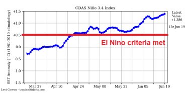
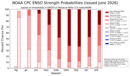
The June 2026 update from the Climate Prediction Center put us in an El Niño based on current observations – and we have an increasing probability to have a strong El Niño by late fall and into winter 2026-2027. Just for reference, a strong El Niño is when those SST’s increase above 2.0°C above normal. What this means is that we have more buoyancy of air with more lifting, and less upper shear over the eastern north Pacific, so they will have a very active year. Meanwhile over the Atlantic basin, the Corolis effect pulls that air from west-to-east and creates a large pool of sinking air with lots of upper shear. This sinking air makes it difficult for tropical cyclones to aggregate storms around a central core with the hinderance of vertical stacking. Additionally, the upper shear tears cloud-tops off as storms try to stack vertically and are blown away from over the core. In short, these two key factors make for large areas of hostile environments where tropical systems would normally form.
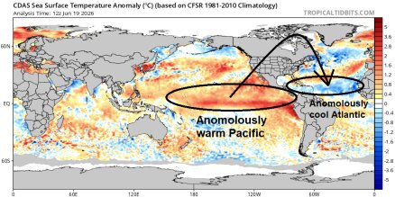
As far as the start of the season as El Nino is just getting cranked up, another factor to why we will likely have a slow start to the season is because we have anomalously cool water across the Main Development Region of the equatorial Atlantic and westwards into the Caribbean Sea. This is indicative of further evidence of sinking air and suppression of warmth over these bodies of water, which typically contain warmer conducive for surface fuel for tropical systems by June. So what does this mean for tropical cyclone development until those waters warm up? It really points to the likelihood that we will be largely looking for homegrown systems that form near our coastlines along old fronts with high pressure to their north giving them some “top spin”. Just to be clear on this point, high pressure spins clockwise while low pressure spins counter-
clockwise. If we have strong high pressure north of a cold front that is near or over the coast, then we can get low pressure(s) to spin up along that boundary. There is an old saying for this in our profession, “Ridge over troubled waters” for the primary indicator when seeing the pattern setting up.
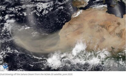
I also would like to discuss is the Saharan Air layer, or “SAL” for short. This is a very unique natural/regular occurrence where strong winds over the Saharan Desert of Africa kick up lots of sand and iron-rich and phosphorous-rich particles that are thrust up into the mid-levels of the atmosphere. These particles are very light and due to buoyancy/lifting of the hot air, they are suspended while traveling east over the Atlantic Ocean and slowly precipitate out over thousands of miles. We call this the “Dry Dusty Tongue” of the Sahara and when the SAL thickens during high wind events, this dust gets entrained into tropical waves that form just off of Africa or even farther west in the Main Development region. It dries out the air an inhibits convection and storming to aggregate around a surface circulation in its earliest stages and can also plague a system that is trying to get its act together. Now this occurrence happens every year regardless of what is happening in the Pacific, so I want to clarify that this is an additive and more of protective feature that tends to keep our hurricane activity down more than it would be without it. In short, the SAL helps prevent many hurricanes from forming through the summer, but relaxes a bit as we get into late summer and fall. Hence the “Cape Verde” season when more storms form off the higher latitude of the equatorial Atlantic off the African coast and make their routine runs to the west.
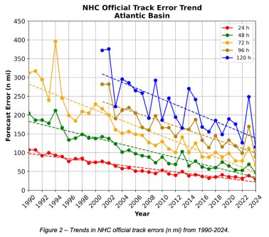
Another key topic to touch on here as we head deeper into the season is our current hurricane forecast accuracy. Honestly, it just keeps getting better and better over time and it is amazing to be in such a rich era of data. The forecast cone of uncertainty has improved in both a reduction
in cone width and a higher accuracy in its track to five days out. There is a new experimental cone to be used this year that will express 90% of the forecast track possibilities instead of the standard 67% forecast error, which means this accuracy is progged to take its next step forward with even better results. Just in the last several years, the NHC has become very accurate within 50-60 miles at one to two days out, within 100 miles at day three and within 200 miles at days four and five. In essence, the cone of uncertainty has shrunk significantly over time and shows continuous improvement. This has a lot to do with not only super-computing power / numerical modeling becoming stronger, but also continued human interactive observation techniques such as hurricane hunters, surface-based weather stations (we at WeatherFlow Tempest contribute to this!) and a better understanding of atmospheric steering patterns.
Speaking of model guidance, there has been a large surge in numerical prediction accuracy as more data is being ingested into the physics and architecture of model ensembles, which host dozens of solutions for each run to develop better mean solutions. Additionally, the statistical, deterministic, probabilistic and dynamic modeling has become stronger as well as time has gone
by. The recent introduction of AI tropical cyclone model guidance by various outfits such as the AIGFS (AI Global Forecast System) in the US, EC-AIFS (Euro) and even Google are showing more and more similarities in their runs, which is a good thing when models become aligned in the medium and short-term solutions. It should be very interesting to see how these models improve over time, but don’t forget that we still very much need human interaction for guidance on these storms as intuitive tropics knowledge still supersedes the computing power we have in many ways.
My final thoughts here will be given to a safety moment for all of us. Let’s always remember that it takes only one land-falling storm to change perspective on what we might perceive as a quiet season ahead. Be sure to develop your evacuation plans and have your hurricane kits updated just in case, especially if you live at the coast. It’s not a matter of IF, it’s WHEN.
Stay safe and stay weather aware out there! Be sure to tune in to our WeatherFlow-Tempest apps and products as we provide all kinds of quality key information for your needs in all things weather!
Sincerely,
Weather-Flow Tempest Meteorologist Shea Gibson